Research Facilitated by the Eco-Informatics Center
The Computational Ecology group works towards developing new tools for application in the field of natural resource management and conservation planning and promoting collaborative research on eco-informatics. Objectives
The new approaches to conservation science at ATREE meet the need for rapid, repeatable, inexpensive and accurate vegetation classification and mapping as well as the need for estimating the degree to which forest habitats have been disturbed over large areas. The use of remotely sensed data and geographic information systems in particular, have provided for the development of useful tools for consistent, replicable and cost-effective monitoring, assessment and management of tropical biodiversity.
Classifying and Mapping Forests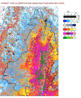
Forests are not mosaics of discrete categories of vegetation types, but are a continuously changing terrain of biological diversity. Earlier methods of mapping did not reflect this. In addition, tropical forests with a distinct dry season have a varying degrees of deciduousness and density. Researchers at ATREE have developed a new method, which builds on the principle that both forest and grassland ecosystems undergo eco-climatic change through the annual cycle. This technique has been developed to generate a continuous mosaic of vegetation change using a satellite-data derived measure called Normalized Difference Vegetation Index (NDVI) values. The mean and Coefficient of Variation (CV) of NDVI were calculated for satellite imageries acquired from three different seasons. Areas of dense greenery (high NDVI) and low seasonality (minimal CV) can be considered to correspond to moist evergreen forests, as evergreen tree species do not shed their leaves during the drier months. While areas with low mean NDVI and high CV would represent scrub forests. . In between there are several levels of deciduousness and tree-density. Thus the mean NDVI and CV can be used as two different axes to represent a continuous gradient of moistness and greeness.Such classification allows for identifying a gradual change in forest type across a large area and is better suited to the classification of tropical forests. This method can be applied to areas where no information on forest types is available. Quantifying Landscape Heterogeneity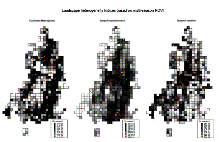
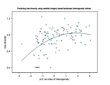
Across the landscape, heterogeneity of habitat at various spatial scales is a strong influence on the distribution of biodiversity. As yet, there is no simple measure of landscape heterogeneity that can be applied to large regions such as the Western Ghats, but ATREE has developed a technique to classify landscape heterogeneity using remotely sensed data and sophisticated statistical models. This technique quantifies landscape heterogeneity within grid cells of 1 to 2 km and has been found to be related to various measures of diversity measured on the ground. ATREE researchers have used a Satellite data derived index called the Normalized Difference Vegetation Index (NDVI) within a given grid cell, combined with the fractal dimension of patches, number of vegetation types within the grid and the magnitude of ecoclimatic heterogeneity amongst the classes present in a grid cell, to define the index of landscape heterogeneity. A grid cell that contains a greater number of vegetation classes which are ecoclimatically very different from each other is likely to provide habitat for a greater diversity of plants and animals. This index has been successfully tested for its ability to predict butterfly and tree diversity within the Biligirirangan wildlife sanctuary in Karnataka. This technique also enables the identification of localized hotspots embedded within the larger biodiversity hotspots.
Modelling of Species DistributionATREE researchers have been collaborating with their international counterparts towards the development and application of species range modelling techniques which are useful in predicting where a species might occur. The principle behind this technique relies on taking actual species occurrences and then developing a niche or habitat model for that species based on other parameters such as climate, soil, geology at the sites where the species actually occurs. This technique is particularly useful in the case of conservation planning applications for lesser known taxa such as insects and amphibians. It also has other significant applications such as the modelling of ranges for pest species, disease vectors or invasive species. Learn more. » Useful Links:
Arcview scripts (Avenue scripts)
For any further information or support for the above scripts - send mails to : Aditya Singh, Former Sr. RA, Eco-Informatics Centre, ATREE | |